March 12th, 2025: Another Round of Valley Rain and Mountain Snow Tomorrow
Synopsis
A low pressure system will move eastward across the Southwest generating gusty winds, cool temperatures, and widespread precipitation tomorrow across the state. Strong southwesterly are likely across the lower deserts (including Tucson and Phoenix) tomorrow morning and early afternoon ahead of the primary cold front. Rainfall amounts will range from a few hundredths to 0.25 inches in the lower deserts and between 0.25 and 1 inch over the mountains. Snow levels are expected to remain above 5000 feet with total snowfall amounts between 1 and 6 inches with higher amounts likely over the tallest mountain peaks above 8000 feet. There is a chance for a few isolated thunderstorms tomorrow due to just enough buoyancy, so a few lightning strikes and small hail are possible.
Current Conditions
As of 2:45PM MST this afternoon, southwest regional satellite imagery overlaid with 500mb RAP analysis displays an upper level trough off the California Coast, shortwave ridging over Arizona, and stratocumulus across the region.
 |
| Southwest regional visible satellite imagery overlaid with 500mb RAP analysis as of 2:45PM MST courtesy of College of Dupage. |
Our next storm system is currently impacting Northern California, and will eventually work its way southeastward into the Southwest by tomorrow.
Tomorrow's Forecast
Dynamics, Moisture and Instability
Synoptic scale ascent is expected across the region midday tomorrow through the early evening hours due to low level convergence along a cold front beneath cyclonic vorticity advection ahead of the upper level trough vorticity maximum.
 |
| 15z UA WRF-HRRR 2-meter dew point temperatures valid at 2:30PM MST tomorrow afternoon. |
 |
| 15z UA WRF 500mb temperatures valid for 3PM MST tomorrow afternoon. |
This system will be accompanied by modest amounts of moisture with our UA WRF IVT product indicating IVT values on the order of 150 to 250 g/kg m/s tomorrow.
 |
| 15z UA WRF-HRRR IVT valid for 2PM MST tomorrow afternoon. |
UA WRF model soundings (and the gridded PWAT map) indicate precipitable water values between 0.6 and 0.9 inches across the lower deserts tomorrow which is quite impressive for March. In fact, based on Tucson sounding climatology these forecast precipitable water values are above the 90th percentile for March.
 |
| 15z UA WRF KPHX (left) and KTUS (right) model soundings valid for tomorrow afternoon. |
Instability will be marginal at best with the UA WRF showing CAPE values on the order of 50 to 200 J/kg. This definitely isn't impressive, but it should be enough for a few isolated thunderstorms tomorrow afternoon.
Timing, Precipitation Amounts, and Impacts
Brisk southwesterly winds will begin tomorrow morning through mid afternoon in response to the tightening pressure gradient as the cold front approaches from the west. The UA WRF forecasts the strongest wind speeds over the higher terrain and across extreme Southern Arizona (including Pima, Santa Cruz, and Cochise Counties) where wind speeds could reach as high as 30 to 40 knots.
 |
| 15z WRF-HRRR 10-meter wind speed valid for tomorrow at 2PM MST. |
 |
| 18z WRF-HRRR 48-hour total accumulated precipitation forecast valid for 18z today to 18z Friday. |
Snow levels will likely remain confined to above 5000 feet with between 1 to 6 inches expected between 5000 and 8000 feet and between 6 and 12 inches above 8000 feet.
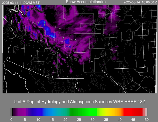 |
| 18z WRF-HRRR 48-hour accumulated snowfall forecast valid for 18z today through 18z Friday. |
Anticipate extremely hazardous traveling conditions especially along I10 east of Casa Grande and I17 between Phoenix and Flagstaff. The evening commutes in Tucson and Phoenix will also be impacted with the main hazards being reduced visibility, localized flooding, and slick roadways.
Precipitation will taper off around midnight tomorrow night.
Friday Through Sunday
A shortwave trough will dive southeastward into Arizona Friday afternoon and evening bringing another round of precipitation to Arizona.
 |
| 18z GFS 500mb cyclonic vorticity valid for 5PM on Friday courtesy of Tropical Tidbits. |
However, this system will be much weaker and drier than the storm system tomorrow with only scattered, mainly light showers expected.
By this weekend, high pressure aloft rebuilds into region bringing a return of drier conditions.
-Tyler


Comments
Post a Comment