March 6th, 2025: Cool, Breezy, and Wet Through Friday Evening
Synopsis
An upper level trough moving eastward into the Desert Southwest will bring cooler temperatures, gusty winds, and chances for precipitation across Arizona through Friday evening. Today will be breezy across the state, and precipitation chances will remain mainly confined to the higher terrain of Northern Arizona due to strong orographic enhancement. By late tonight into tomorrow morning, a vorticity maxima will generate widespread valley rain and mountain snow showers across the state. Rainfall amounts will range from a trace to 0.50 inch in the lower deserts and between 0.5 and 1.5 inches over the mountains, with highest amounts over the Mogollon Rim. Snow level will fall to around 4000 feet tomorrow morning with models forecasting a trace to 6 inches between 4000 and 6000 feet and between 6 and 12 inches above 6000 feet with locally higher amounts possible over the tallest peaks of Northern Arizona.
Over the weekend, high amplitude ridging rebuilds into the Southwest, diminishing precipitation chances across our region.
Current Conditions
As of 9:30AM MST, visible satellite imagery shows mid and high clouds across Central and Eastern Arizona.
 |
| Visible satellite imagery as of 9:30AM MST courtesy of College of Dupage. |
The 12z GFS 500mb analysis displays an upper level trough axis oriented along the California Coast and brisk southwesterly flow across Arizona.
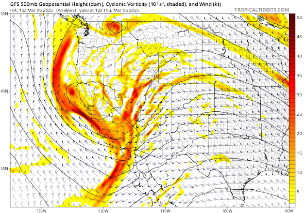 |
| 12z GFS 500mb analysis courtesy of Tropical Tidbits. |
Surface observations indicate breezy southwesterly winds across the state with gusts reported as high as 40 knots over the higher terrain.
 |
| Surface observations as of 9:45AM this morning courtesy of the NWS. |
Today
Precipitation chances today will mainly remain confined to the higher terrain of Northern Arizona due to strong orographic lift. Rainfall amounts over the mountains will range from a trace to 0.25 inch with locally higher amounts possible over the tallest peaks. Otherwise, the lower deserts should remain mostly dry, but the main forecast highlight is the gusty winds. Wind speeds will peak around early afternoon with strongest winds in Northern Arizona, Cochise County, and New Mexico as shown below.
 |
| 12z UA WRF-HRRR 10-meter winds valid for 2PM MST this afternoon. |
Late Tonight Through Friday Evening
Dynamics and Moisture
By tonight, a vorticity maxima embedded within the broad trough will continue diving southeastward along the California coast and will amplify over Southern California. This feature will provide Arizona with synoptic scale ascent induced by CVA late tonight through Friday afternoon.
 |
| 12z GFS 500mb cyclonic vorticity valid for tomorrow at 12z courtesy of Tropical Tidbits. |
As far as moisture is concerned, UA WRF Integrated Water Vapor Transport (IVT) indicating values on the order of 100 to 200 g/kg m/s across Arizona.
 |
| 12z WRF-HRRR IVT valid for 11PM MST tonight. |
This will help moisten the lower half of the troposphere as indicated by KTUS and KPHX model soundings shown below.
 |
| 12z WRF-HRRR KPHX (left) and KTUS (right) soundings valid for 8AM MST tomorrow. |
Precipitable water isn't very impressive (< 0.5 inches), but a nearly saturated column should be sufficient for moderate precipitation rates.
Timing, Amounts, and Impacts
UA WRF ensemble members are in good agreement regarding the timing of precipitation. Precipitation is expected to begin in western AZ around midnight tonight, and shift into Central and Eastern Arizona after sunrise. The main precipitation band will persist across the Eastern half of Arizona through early afternoon before shifting into New Mexico by sunset.
There's some disagreement among UA WRF ensemble members regarding total precipitation amounts with the 12z and 15z WRF-HRRR showing less precipitation compared to the 06z WRF-GFS. I'm leaning toward the 15z WRF-HRRR as it appears to be the most reasonable solution. Rainfall amounts in the lower deserts will range from a trace to 0.50 inches, and between 0.50 and 1.5 inches over the mountains with locally higher amounts possible.
 |
| 15z WRF-HRRR 36-hour accumulated precipitation forecast valid for 8AM MST this morning through 8PM MST Saturday evening. |
Snow levels will remain mainly above 4000 feet late tonight through Friday afternoon. Periods of heavy snowfall is possible, especially in Northern Arizona where orographic lift will be maximized due to IVT vectors orthogonal to the orientation of the Mogollon Rim. I would expect between a dusting to 6 inches of snowfall between 4000 and 6000 feet, and between 6 and 12 inches above 6000 feet with locally higher amounts possible over the tallest peaks.
 |
| 15z WRF-HRRR 36-hour accumulated snowfall forecast valid for 8AM MST this morning through 8PM MST Saturday evening. |
The majority of accumulated precipitation will occur within the primary precipitation band, but CAMs show a chance for scattered afternoon and early evening convection across the Eastern half of Arizona. There should be some clearing by the afternoon which would allow the surface to heat and combined with colder air aloft would steepen low and mid level lapse rates. UA WRF model soundings only indicate around 100 to 200 J/kg of CAPE which makes sense considering the cold(ish) surface temperatures and modest moisture.
 |
| 12z KPHX (left) and KTUS (right) WRF-HRRR soundings valid for 3PM MST tomorrow afternoon. |
In addition, the region will still be under CVA and combined with modest instability should be sufficient for scattered convective showers and isolated low-topped thunderstorms. Main impacts from these showers/t-storms would be brief heavy rain, small hail, and isolated lightning strikes.
This Weekend Into Early Next Week
By this weekend, high amplitude ridging will rebuild into the Southwest bringing a return of drier weather and warming temperatures.
 |
| 12z GFS 500mb cyclonic vorticity valid for Sunday at 18z courtesy of Tropical Tidbits. |
The deterministic GFS and ECMWF as well as their ensemble members continue to show an active pattern across the Southwest heading into next week. Could this be a Miracle March for Arizona? We shall see!
-Tyler


Comments
Post a Comment