November 2nd, 2024: Valley Rain and Mountain Snow on Sunday
Synopsis
A mid latitude trough is expected to continue to dig southeastward along the West Coast throughout the day today and eventually reach Arizona later tonight. This feature will allow 500mb heights to fall leading to much cooler temperatures as well as a chance for valley rain showers and mountain snow across mainly the eastern half of the state. In addition, UA WRF model soundings forecast a relatively shallow layer of instability (CAPE on the order of 100 to 300 J/kg) tomorrow across the region, so an isolated low-topped thunderstorm or two is possible. Rainfall amounts are expected to be light, with between a trace to 0.10 inches in the lower deserts, and between 0.25 and 0.50 inches over the higher terrain with highest amounts possible along the southwestern facing slopes of the Mogollon Rim and White Mountains. Snow levels will remain above 6000 feet with a trace to 6 inches expected with locally higher amounts possible over the tallest peaks.
Current Conditions
At 3PM MST, visible satellite imagery overlaid with SPC 500mb RAP analysis displays a stream of mid and high clouds moving northeastward across Northern Arizona ahead of the 500mb trough axis, and an area of showers moving eastward across the Southern California Bight.
Visible satellite imagery overlaid with 500mb RAP analysis at 3PM MST courtesy of College of Dupage.
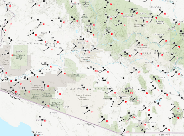
Surface observations as of 3:15PM MST courtesy of the NWS.
Synoptics/Dynamics
The aforementioned 500mb trough will gradually move southeastward into Arizona overnight and into tomorrow morning. This trough is expected to dig southeastward and amplify over Arizona due to a region of maximum cyclonic shear vorticity upstream of the trough axis acting to amplify the wave.

12z GFS 500mb cyclonic vorticity valid for 11AM MST tomorrow courtesy of Tropical Tidbits.
I'm also seeing some veering in the model soundings which implies warm advection (signature for ascent), but "temperature advection" in complex terrain most likely won't be the primary synoptic scale mechanism for ascent.
Moisture and Instability
As would be expected, this system is quite moisture starved with the UA WRF forecasting precipitable water in the 0.50 to 0.75 inch range tomorrow.

12z WRF-HRRR precipitable water valid for 8AM MST tomorrow.
Anyway, buoyancy will be very limited which is to be expected, but KTUS model soundings show a relatively shallow layer of instability with forecast CAPE values on the order of 100 to 300 J/kg tomorrow morning as shown below.
 |
| 12z KTUS WRF-HRRR sounding valid for 9AM MST tomorrow. |
Compared to monsoon standards this isn't a lot of CAPE, but it's just enough to warrant a chance for an isolated thunderstorm or two.
Timing, Impacts, and Precipitation Amounts
I'm using the 12z WRF-HRRR for this analysis as I didn't see any real significant difference between the 12z, 15z and 18z ensemble members. CAMs forecast showers to begin developing around midnight tonight mainly in Gila County as well as extreme Northeast Maricopa and Pinal Counties which even includes the Phoenix vicinity.

12z WRF-HRRR simulated reflectivity valid for 11PM MST tonight.
 |
| 12z WRF-HRRR simulated reflectivity valid for 8AM MST tomorrow. |
The best timeframe for precipitation in Tucson will likely be during the late morning to early afternoon hours (between 9AM and 1PM MST).

12z WRF-HRRR simulated reflectivity valid for 11AM MST tomorrow.
By mid afternoon, shower activity is expected to remain confined mainly to the higher terrain north and east of the major population centers (Phoenix and Tucson).

12z WRF-HRRR simulated reflectivity valid for 3PM MST tomorrow.
CAMs do hint at the potential for a few isolated early evening showers in the lower deserts of eastern Maricopa (including Phoenix), Pinal, and Pima (including Tucson) Counties, but I wouldn't expect much.
Most of the precip is expected to shift east into New Mexico late tomorrow night with a few remnant showers possible over the White Mountains.
As mentioned above, there is an isolated chance for thunderstorms, but considering the minimal instability I wouldn't expect more than a few rogue lightning flashes and maybe an instance of small hail.
Precipitation amounts are expected be light as models forecast between a trace to 0.10 inches in the lower deserts and between 0.25 and 0.50 inches over the higher terrain. However, amounts as high as one inch or more are possible along favorable southwestern facing mountain slopes due to orographic enhancement.

12z WRF-HRRR 48-hour total accumulated precipitation forecast valid between 12z 11/2 to 12z 11/4.
12z WRF-HRRR 48-hour total accumulated snowfall forecast valid between 12z 11/2 to 12z 11/4.
I'm not anticipating any significant impacts to traveling in the lower deserts as precipitation will remain very light and I don't see any risk for high winds. However, I would definitely anticipate hazardous traveling conditions over the higher terrain, especially for anyone driving to Flagstaff along I17.
Lastly, it will be on the chilly side tomorrow with daytime temps in Phoenix and Tucson likely remaining in the 60s.
 |
| 12z WRF-HRRR 2-meter temps valid for tomorrow at 2PM MST. |
Early Next Week
By Monday, the aforementioned 500mb trough will lift northward into the Plains with transitory ridging building into Arizona ending any chance for precipitation.

12z GFS 500mb cyclonic vorticity valid for 06z Tuesday courtesy of Tropical Tidbits.
High temperatures should remain slightly below normal early next week, and models are hinting at another trough/upper level low to dive southward into the region by the latter half of the week. So......stay tuned for that!


Comments
Post a Comment