June 30th: It's a Wild World.....
Overview:
As Hurricane Beryl is poised to potentially become the earliest Atlantic Basin category 4 storm in the satellite era as it bears down on the Windward Islands of the Carribean, southeastern Arizona is facing its own set of weather challenges. Relatively saturated soil from activity over the past 48 h combined with the potential for significant rainfall today has led the Weather Prediction Center (WPC) to place southeastern Arizona in a slight risk area for excessive rainfall. This indicates at least a 15% chance of rainfall exceeding flash flood guidance in a 25 mile radius around any point in the slight risk area. This also corresponds to a National Weather Service (NWS) Issued flood watch. Additionally, the Storms Prediction Center (SPC) has indicated a marginal risk (5% chance) of severe winds in our region and corresponds with a blowing dust advisory issued by the NWS.
The threat of severe convection is being supported by a combination of deep moisture being advected into our region by deep southeasterly flow around an anomalously strong anticyclone centered over Texas this morning in combination with a trough over the West Coast. The combination of these features places Arizona in a relatively favorable pattern for synoptic scale ascent which should help support convection in our region for the next few days. It should be noted however that early day cloud cover may dampen expected intensity/covera in Day to day changes in cloud cover and the exact placement/evolution of the trough over the next few days will create some variation in the likelihood of convection from day to day.
Today:
Hurricane Beryl
I will start today's discussion with a quick look at Beryl because I think it's too interesting to ignore. As of 8 AM MST the National Hurricane Center (NHC) had Beryl as a major hurricane with sustained winds of a 105 knots. This morning's satellite image shows a classic symmetric hurricane with a clearly defined eye.
Vis Satellite of Beryl valid at 10 AM MST
(weather.cod.edu)

Beryl is forecast to become a category 4 Strom with wind speeds of 120 knots by this evening making an historic storm as the earliest category 4 storm in the Atlantic Basin on record, with the previous record being July 7th. Also making this storm unique is the fact that it rapidly intensified and attained major hurricane status out in the central Atlantic which does not usually become active until later in the season. The storm is expected to cross and Windward Islands and make its way through the Carribean over the next several days.
Forecast track of Beryl
(nhc.noaa.gov)

Closer to Home
The SPC mesoanalysis at 500 hPa gives us a good picture of the players involved in today's forecast.
500 hPa mesoanalysis valid at 10 AM MST
(spc.noaa.gov)

They include the high pressure system centered in Texas, the though along the California Coast, and an inverted trough or vorticity center along the AZ/Mexico border. This later feature was associated with overnight convective activity an is in part responsible for cloudiness this morning. Behind this feature, southeasterly 500 hPa flow has increased and should aid in propagation of storms and outflow boundaries to the northwest. Activity immediately to the east of this feature should be suppressed, but this feature is forecast to lift northward later today.
This morning's sounding continues to show impressive precipitable water values of 1.5"
12Z KTUS sounding (5 AM MST)
(spc.noaa.gov)

These values are consistent with the UAWRF's forecast from both the 12Z and 15Z HRRR intializations
Comparison of 12Z(left) and 15Z(right) UAWRF CAPE valid at 1:30 MST
(weather.arizona.edu)

Clearing is slowly taking place from west to east behind this feature but I am somewhat concerned about a plume of mid-level clouds moving through eastern Pima County as of 11 this morning.
Vis Satellite valid at 11 AM MST
(weather.cod.edu)

In conjunction with this is a pretty sharp gradient in surface based CAPE across Cochise County in the SPC mesoanalysis, although it should be noted that these values already exceed the forecast CAPE values. Meanwhile, the convective Inhibition is a little slower to burn off in the region of cloud cover.
Surface Based CAPE mesoanalysis valid at 11 AM MST
(weather.cod.edu)

However, in spite of my concerns about conditions that might limit convective intensity, most CAMs are fairly bullish on activity today, however there seems to be a trend to holding off heavier/more widespread activity until later in the day. This can be seen in a comparison of the UAWRF 12Z (right) and 15Z (left) HRRR intitializations, witn the 15Z run showing slightly less widespread activity at 3:30 PM MST.
Comparison of 12Z(left) and 15Z(right) UAWRF reflectivity valid at 3:30 MST
(weather.arizona.edu)

17Z HRRR reflectivity forecast valid at 7 PM MST
(spc.noaa.gov)
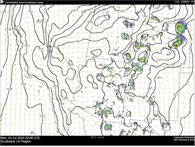
Given the current analysis and forecasts, I would expect the greatest threat to occur after 5 PM. Additionally, my greatest concern for flooding would be the areas just southeast of Tucson along the I-10 corridor and the adjoining areas bordering Santa Cruz and Cochise Counties. I should note that the HRRR ensembles from 12Z this morning show at least a 50% chance of greater than 1" throughout eastern Pima county, so I would not be dismissive of the possibility of flash flooding in the metro area, but I am less confident of that now than I was when I woke up this morning.
Comparison of 12Z(left) and 15Z(right) UAWRF 500 hPa vorticity valid at 5:30 PM MST
(weather.arizona.edu)

Tomorrow:
12Z HRRR ensemble mean 500 hPa flow valid at 2 PM MST
(spc.noaa.gov)

The axis of greatest instability should shift from just east and south of Pima county (today) into central and eastern Pima county.
12Z HRRR ensemble mean CAPE valid at 12 PM MST
(spc.noaa.gov)

Surface convergence along this axis should result in convective initiation relative early in the day provided clear morning skies.
12Z UAWRF HRRR reflectivity valid at 3 PM MST
(spc.noaa.gov)


Comments
Post a Comment