June 29th, 2024: Extensive Cloud Cover to Suppress Convection Today; Much More Active Tomorrow
Synopsis
Mid level clouds associated with an MCV from overnight convection in Sonora will likely suppress storm development through this afternoon. Isolated storms will be possible in any areas that can receive enough clearing. CAMs are hinting at the possibility of organized storms in Sonora moving northwestward into SE AZ later this evening into the overnight hours. This activity looks to slowly weaken as it moves into Arizona. Tomorrow looks to be a very active day across SE AZ with more widespread storm coverage and possible significant impacts.
Yesterday/Monsoon 2024 Climo
An active day across SE AZ yesterday with quite a few strong cells in the Tucson vicinity. Tucson International Airport received 0.70 inches and other gauges across the area receiving widely variable amounts from a trace to close to one inch. A couple storms had wind gusts reach severe criteria with reports of a 58 mph gust and a few trees uprooted via SPC storm reports.
 |
| SPC Storm Reports yesterday for Pima County. |
Since we are about to close the door on the month of June, I wanted to briefly discuss current climo for this season as it's impressive. As of yesterday (June 28th) Tucson Airport has received 1.07 inches which is well above the 1990 - 2020 average of 0.14 inches by June 28th. Nogales and Sierra Vista have received just above 1.50 inches which is well above the 1990 - 2020 average of approximately 1/3 of an inch.
 |
| 2024 Monsoon Rainfall vs. Normal graph courtesy of NWS Tucson. |
 |
| Tucson Airport 2024 dew points compared to 1946-2021 average courtesy of NWS Tucson. |
At 10:00AM MST, visible satellite imagery displayed widespread mid level clouds across the eastern third of AZ associated with a couple MCVs from overnight convection in Sonora (one near Tucson and another just south of the Border).
 |
| Visible satellite imagery overlaid with GOES GLM flashes at 10:00AM MST courtesy of College of Dupage. |
It is very muggy this morning across the Tucson area with dew points in the mid to upper 60s and temps in the upper 80s to low 90s.
 |
| Surface observations as of 10:00AM MST courtesy of the NWS. |
 |
| SPC 500mb analysis as of 17z this morning. |
Still plenty of moisture and some instability with the 12z TUS sounding measuring around 1.50 inches of pwat and around 700 J/kg of CAPE.
 |
| 12z TUS sounding courtesy of the SPC. |
 |
| SPC mesoanalysis of CAPE and CIN as of 10:00AM MST this morning. |
Synoptics
The mid level subtropical high will continue to build northward throughout the day and remained centered near Texas with southeasterly/southerly flow aloft in AZ.
 |
| 12z GFS 500mb absolute vorticity valid for 18z today courtesy of Tropical Tidbits. |
Even with the mid level high well to the east and a favorable southeasterly/southerly mid level flow, the synoptics/kinematics are leaning on the unfavorable side for a couple of reasons. First, well ahead of the inverted trough is shortwave ridging which generates anticyclonic vorticity advection (mechanism for descent). As the MCV near the Border moves northward, additional anticyclonic vorticity advection is left in its wake. The weak subsidence induced by these features aren't strong enough to completely suppress thermodynamically driven convection, but combined with extensive, lingering cloud cover will make convective initiation a difficult task today. Also, we don't have the additional upper level divergence like we did yesterday which helped updrafts breach the subsidence inversion at 500mb.
Thermodynamics
Even with plenty of moisture and CAPE today, extensive cloud cover persisting into the afternoon hours will inhibit widespread insolation. This will make it difficult for the boundary layer to become well-mixed and for CIN to erode. CAMs seem to be in good agreement with this as the 12z KTUS WRF-HRRR sounding forecasting mixed layer CIN to hang around -100 J/kg throughout the afternoon hours.
 |
| 12z KTUS WRF-HRRR sounding for this afternoon at 3:00PM MST. |
What to Expect/Impacts
Overall, based on current guidance, expect somewhat of a "down day". Subtle anticyclonic vorticity advection combined with persistent cloud cover will make convective initiation difficult to achieve. Any location that can receive significant clearing has the chance to produce a storm or two, but based on CAM solutions activity should remain isolated and mainly confined to the higher terrain.
 |
| 12z (left) and 15z (right) WRF-HRRR simulated reflectivity for this afternoon at 5:00PM MST. |
Any storm that develops will be able to produce lightning, gusty winds, and brief heavy rainfall.
The cloud cover should keep high temps a few degrees cooler today especially in SE AZ where temps will likely remain at or below 100 degF. Temps between 105 and 110 degF are expected this afternoon in the lower deserts between Phoenix and Yuma.
 |
| 12z WRF-HRRR 2-meter temps for this afternoon at 3:00PM MST. |
Tonight's Forecast
As the inverted trough approaches from the southeast, the synoptics become more favorable as cyclonic vorticity advection begins to dominate the mid levels.
 |
| 12z GFS 500mb absolute vorticity at 11:00PM MST tonight courtesy of Tropical Tidbits. |
 |
| 12z (left) and 15z (right) WRF-HRRR simulated reflectivity for tonight at 1:00AM MST. |
 |
| 12z KTUS WRF-HRRR sounding for tonight at 1:00 AM MST. |
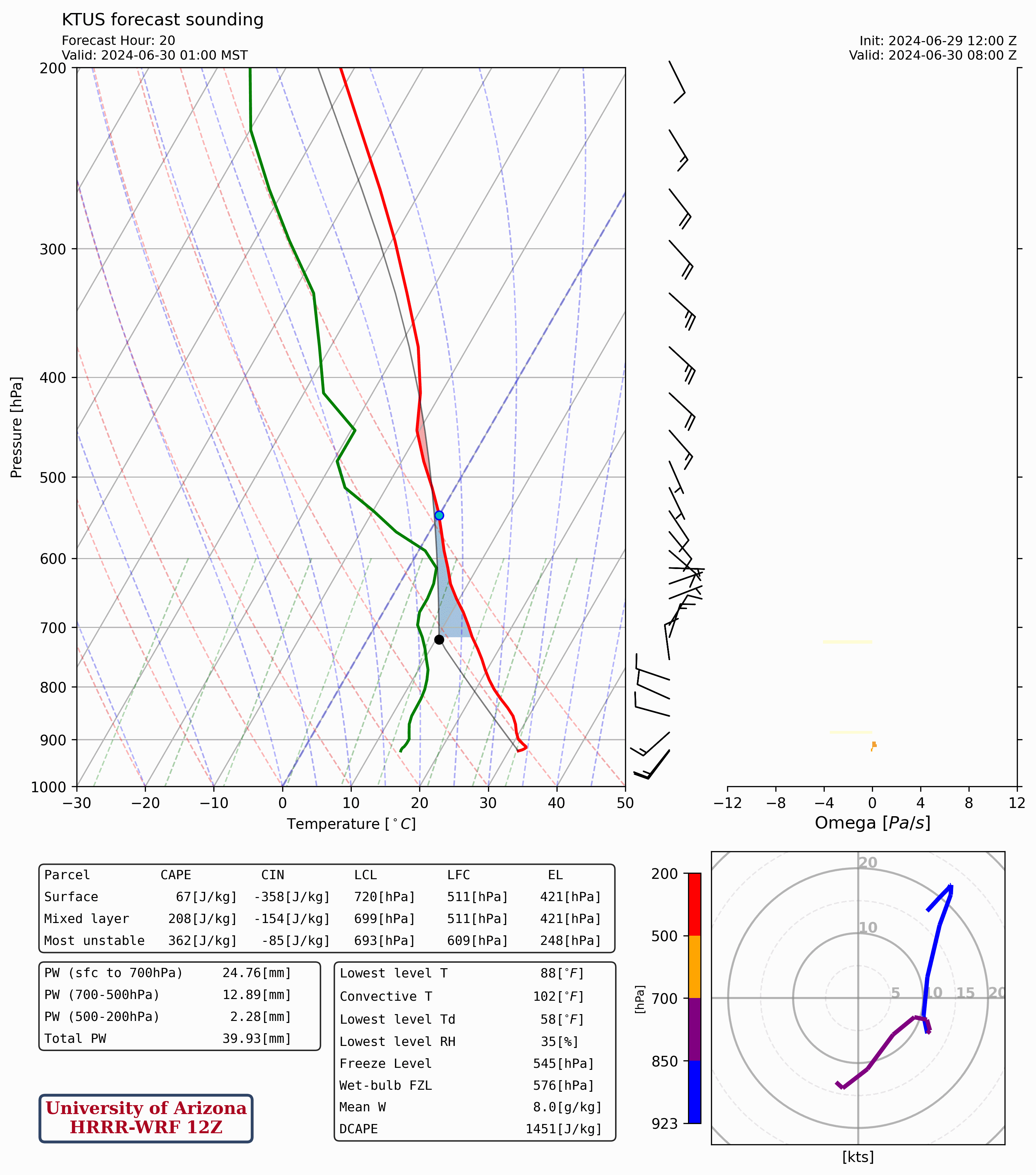
Can't completely rule out a few isolated, showers and storms in the Tucson vicinity tonight, but based on current guidance the most widespread and intense storms will remain south and east of Tucson.
Tomorrow's Forecast
By tomorrow, the mid level high will marginally amplify in response to a deepening trough in the Pacific Northwest, and the center of the ridge shifts farther east toward ArkLaTex. In AZ, the aforementioned inverted trough will be overhead in SE AZ with brisk 20 to 30 knot southeasterly flow aloft.
 |
| 12z GFS 500mb absolute vorticity for tomorrow at 11:00AM MST courtesy of Tropical Tidbits. |
This is a much more favorable synoptic mid level pattern for monsoonal thunderstorms. In addition, the 12z KTUS WRF-HRRR sounding forecasting decent thermodynamics with pwats around 1.50 inches, 1200 J/kg of CAPE, and DCAPE over 1500 J/kg.
 |
| 12z KTUS WRF-HRRR sounding for tomorrow at 1:30PM MST. |
DCAPE around 1500 J/kg combined with some vertical wind shear could produce some convective organization.
Models forecasts storms to impact Tucson sometime by the middle to late afternoon.
 |
| 12z WRF-HRRR simulated reflectivity for tomorrow afternoon at 4:00PM MST. |
Current guidance hints at the possibility for a few short-lived cells to develop in Phoenix, but the majority of activity will likely remain confined to SE AZ.
SPC Day 2 Outlook has SE AZ in general thunder, but I'd expect them to issue marginal risk as the 12z HREF has a 70% to 90% probability of 4-hour max wind speeds exceeding 30 knots across SE AZ.
 |
| 12z HREF 4-hour max wind speed and prob of wind speeds greater than 30 knots for tomorrow at 5:00PM MST courtesy of SPC. |
The 12z HREF also forecasting some areas in eastern Pima County having 4-hour max wind speeds between 40 and 50 knots.
Besides wind, the WPC has Santa Cruz and Eastern Pima County (including Tucson) in a slight risk for excessive rainfall tomorrow.
 |
| WPC Day 2 Excessive Rainfall Outlook. |
Overall, it looks like tomorrow will be the most active day in SE AZ so far this season. Major impacts are possible which include flash flooding, damaging wind gusts, and blowing dust. Considering brisk southeasterly steering flow and DCAPE near 1500 J/kg, a Haboob could develop along the I10 corridor between Tucson and Phoenix. Stay tuned!


Comments
Post a Comment