June 27th, 2024: Storm Chances Mainly Confined to Higher Terrain Today and Tomorrow
Synopsis
The mid level anticyclone will remain centered near the AZ/MX border today and tomorrow with westerly flow aloft over AZ. Even with an unfavorable upper air pattern, sufficient moisture and instability remains in place for a chance of afternoon and early evening showers and thunderstorms over the higher terrain today and tomorrow. Even though convection should remain outside the major population centers, there remains a slight chance for an isolated cell or two to reach the Tucson vicinity today and tomorrow. Marginal drying and a closer ridge center will raise high temps a few degrees but should remain just below excessive heat criteria.
Current Conditions
At 9:00AM MST, visible satellite imagery and lightning detection displayed a localized area of strong thunderstorms along I40 east of Flagstaff and scattered high clouds across SE AZ.
 |
| Visible satellite imagery overlaid with GLM flashes at 9:00AM MST courtesy of College of Dupage. |
The synoptic pattern has changed considerably over the past 24 hours due to a trough moving into the Pacific Northwest flattening the mid level subtropical ridge and displacing the center near the AZ/MX Border.
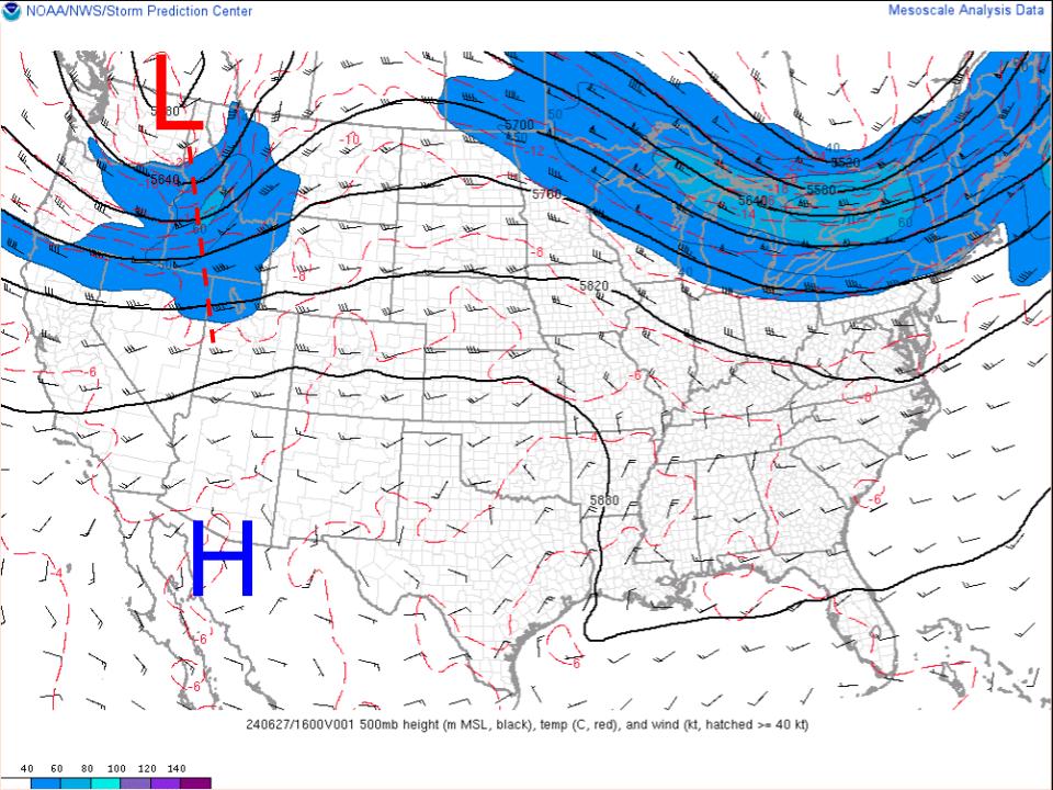 |
| SPC 500mb analysis as of 9:00AM MST this morning. |
Predominantly westerly flow aloft over AZ today which is typically an unfavorable upper air pattern for convection during the Monsoon.
Even with the unfavorable synoptic pattern, there is still plenty of low level moisture across the region with pwats between 1.25 and 1.75 inches as indicated by current SPC mesoanalysis and the 12z TUS sounding.
 |
| SPC mesoanalysis of total precipitable water and 850mb moisture transport vectors valid for 9:00AM MST this morning. |
 |
| 12z TUS sounding courtesy of the SPC. |
 |
| SPC mesoanalysis of CAPE and CIN as of 9:00AM MST this morning. |
Today's Forecast
Synoptics
A relatively more unfavorable synoptic pattern today due to a closer proximity of the center of the ridge and drier westerly flow aloft over AZ. The high isn't very strong luckily due to the passage of a trough in the PacNW limiting the amplitude of the ridge with the center remaining below 594 dm. This should keep high temps below excessive heat criteria today.
 |
| 12z GFS 500mb absolute vorticity valid at 18z today courtesy of Tropical Tidbits. |
Weak subsidence induced by the closer proximity of the subtropical high will have an overall negative impact on instability today particularly in SE AZ. In fact, the 12z KTUS WRF-HRRR sounding reflects this as it shows a layer of slightly warmer mid level temps and less steep mid level lapse rates.
 |
| 12z KTUS WRF-HRRR sounding valid for this afternoon at 4:00PM MST. |
What to Expect/Impacts
Overall, expect a low grade monsoon pattern today with storms remaining mainly confined to the higher terrain. CAMs suggest convection will initiate around 2PM MST this afternoon near the International Border and over the Sky Islands in SE AZ.
 |
| 12z WRF-HRRR simulated reflectivity for this afternoon at 2:00PM MST. |
DCAPE of 1500 J/kg will promote the potential for potent outflow boundaries to initiate new cells with the primary focus in SE AZ east of I19 and south of I10 in Santa Cruz and Cochise Counties. From the KTUS model sounding, brisk 30 to 40 knot southerly winds near the tropopause could lead to anvil cloud cover north of thunderstorm cores which may cause some issues with inhibiting surface heating.
 |
| 12z WRF-HRRR simulated reflectivity for 5:00PM MST this afternoon. |
Storm activity reaching Tucson cannot be completely ruled out with some runs of the HRRR this morning forecasting a few weak, short-lived cells developing in the Tucson vicinity this evening. However, considering the westerly flow aloft and a slightly more hostile environment this seems unlikely. Tucson would need to remain clear of anvils and a strong outflow boundary to initiate convection which isn't impossible.
The SPC thunderstorm outlook reflects the probabilities for storm chances quite well with 40% chances in extreme SE AZ and 10% in eastern Pima County and Western Santa Cruz County.
 |
| SPC Thunderstorm Outlook for this afternoon between 1PM MST and 5PM MST. |
For the most part, scattered showers and storms are possible mainly south and east of Tucson this afternoon and evening. Main impacts will be lightning, gusty winds, blowing dust, and brief heavy rainfall.
Traveling conditions will be hazardous along I19 in Santa Cruz County as well as along I10 in Cochise County with the main threat being reduced visibility due to blowing dust.
Besides convection, temps will be a few degrees warmer today due to a bit of drying and a closer ridge center. High temps should remain just below excessive heat criteria with temps between 100 and 105 degF in SE AZ and between 105 and 110 degF between Phoenix and Yuma.
 |
| 12z WRF-HRRR 2-meter temps for this afternoon at 3:00PM MST. |
Northern Arizona
I wanted to provide a brief note on Northern AZ as the most significant activity is expected there today. Upper level divergence and weak cyclonic vorticity advection induced by a subtle shortwave embedded in the westerlies is already leading to organized storms along the I40 corridor east of Flagstaff. The 12z KFLG (Flagstaff) WRF-HRRR sounding forecasting around 1500 J/kg of CAPE and a weak veering vertical wind profile this afternoon.
 |
| 12z KFLG WRF-HRRR sounding for 12:00PM MST this afternoon. |
SPC has extreme Northern AZ in marginal risk today with a 5% chance of wind gusts and hail reaching severe criteria. Activity should end around sunset.
Tomorrow
By tomorrow, the trough in the Pacific Northwest will move east into the Northern Plains with the mid level subtropical high remaining anchored along the AZ/MX border and weak westerly winds aloft over the region. Not much change to the synoptic upper air pattern in Southern AZ, but Northern AZ will have a much less favorable pattern due to weaker winds aloft and lack of a synoptic scale feature to generate lift/convective organization.
 |
| 12z GFS 500mb absolute vorticity for tomorrow at 11:00AM MST courtesy of Tropical Tidbits. |
Also not expecting much change to the thermodynamics with the 12z KTUS WRF-HRRR sounding forecasting pwats hanging around 1.50 inches, CAPE just north of 1000 J/kg, DCAPE around 1500 J/kg, and weak subsidence above 500mb for tomorrow afternoon.
 |
| 12z KTUS WRF-HRRR sounding for tomorrow at 2:00PM MST. |
Even with near identical conditions, CAMs forecasting a different outcome tomorrow compared to today. Both the 12z and 15z WRF-HRRR solutions forecasting a somewhat organized cluster of storms moving from east to west along the International Border.
 |
| 12z (left) and 15z (right) WRF-HRRR simulated reflectivity for tomorrow afternoon at 4:00PM MST. |
Will need to keep an eye on model solutions to see if there is some run-to-run consistency with this outcome. For now, expect storms to remain confined to mainly the Sky Islands and near the International Border tomorrow in SE AZ.


Comments
Post a Comment